Whiteleaf and Cadsden – A History of Residential Settlement
2.1 History of the area
The hamlet of Whiteleaf originated as a cluster of houses along a track, the Upper Icknield Way, at the foot of Whiteleaf Cross on the Chiltern Escarpment outside Princes Risborough. It is believed that the earliest property, Greenways, dates from the early 16th century (c.1540). The Upper Icknield Way was metalled in the 1830s, which led to further development. However in 1904, Peters Lane was still a chalk road without houses. Today the hamlet has extended along the Upper Icknield Way, with later development in Peters Lane and in Westfields. Cadsden, which straddles the road linking Askett and Great Missenden, also originates from the 16th century and the first properties were farm cottages.
The Icknield Way was used by men and animals and linked Thetford in Norfolk with Avebury in Wiltshire. The track was developed for communication between neolithic centres between 3000 and 1800 BC, traces of which remain in the Ridgeway and the Upper Icknield Way. Roughly midway along this ancient route it crosses a gap in the Chilterns and a similar North/South trade route from the Midlands. Unsurprisingly a settlement developed around this junction, which today is Princes Risborough.
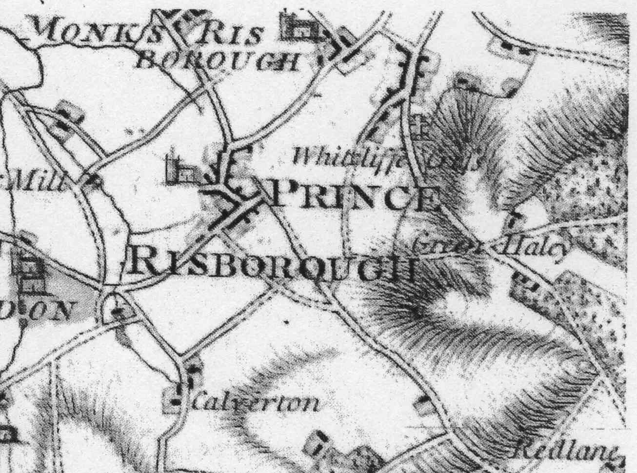
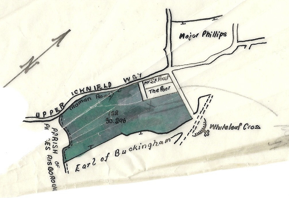
There is some doubt about the route of the Upper Icknield Way through Whiteleaf, as some early maps (see map above from 1777 by John Andrews and Andrew Dury) show that it came across the foot of Whiteleaf Cross and passed through the grounds of what is now Whiteleaf House to join the current road just before the Red Lion, where Whiteleaf Cottage now stands. Currently it is now just a hollow but is significant enough to be marked on the Ordnance Survey map.
The area around Whiteleaf and Cadsden has an ancient history, the oldest part being the Neolithic long barrow above Whiteleaf Cross. The Cross has no great antiquity and many theories abound as to its origin.An interesting text can be found in Benjamin Chilton’s The Secret of Whiteleaf Cross. In addition, F. G. Parsons, who lived in Orchard Cross discusses the origins of the Cross in part 3 of his “Old Records of Monks Risborough” (see further below). The earliest known representations of the Cross were recorded by the Rev. Francis Wise in 1738 and for the antiquarian Browne Willis in 1742. See also a short history of Whiteleaf Cross by Sandy Macfarlane – click here.
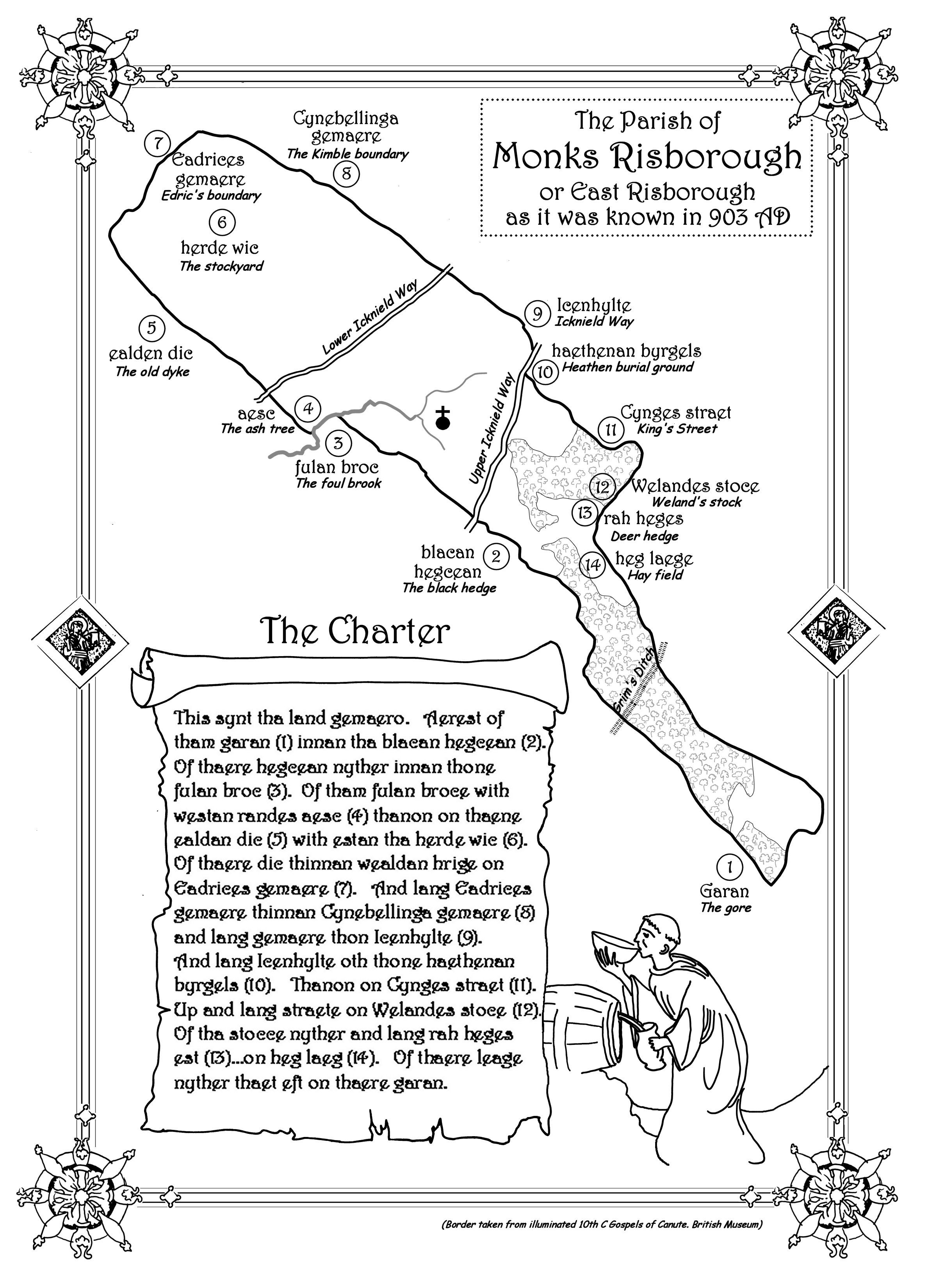
An original Charter (in the British Museum) dated AD 903 (see above) describes land in the vicinity of Monks Risborough as “Eastern Hrisanburge”. To view the Charter map and the Saxon and Latin translations click here. The Doomsday Book entry for Monks Risborough is also available to view by clicking here.
The description makes no mention of Whiteleaf as the hamlet was probably of a much later origin. However reference is made to a King’s Street which marked the boundary of King Ethelgyth’s kingdom. According to Leonard Bull (The Icknield Halfway House), Kings Street is part of an old route to High Wycombe from Askett and ran across the front of the Plough at Cadsden (as opposed to climbing the hill towards Longdown farm as it does today) and took the course of an old bridleway, which eventually curved up a long narrow valley and climbed gradually through Ninn Wood to reach the crest at Green Hailey. The bridleway was known in medieval times as The Killington Track.
The ancient parish boundaries of Monks Risborough and Kimble (within which part of Cadsden lies) followed a regular pattern. They were organised in long narrow strips, with the long side at right angles to the Icknield Way. This gave each parish a portion of hills, meadows and woodland and each measured approximately 6 to 8 miles long and 1 to 2 miles wide.
The parish of Monks Risborough is one of the oldest in England, originating from 903AD, when it was known as East Risborough and was part of the Kingdom of Mercia. Following a fire, which destroyed the landbooks, King Edward the Elder authorised Earldorman Aethelfrith to reproduce them. This resulted in the Charter defining the parish of Monks Risborough. Many of the ancient features which mark the boundary of the Parish, such a The Black Hedge still exist today. “Beating the Bounds of Monks Risborough Parish” by Jane Rogers and Venetia Lascelles describes the boundary in detail and is based on the very comprehensive work of Dr. Arnold Baines. Dr. Baines’ study was first published in Records of Buckinghamshire (the Journal of the Architectural and Archaeological Society for the County of Buckinghamshire) in 1981 and can be accessed via by clicking here. At some point between 903AD and the Norman Conquest East Risborough became the property of the monks of Christ Church Canterbury.
F. G. Parsons, in part 1 of his “Old Records of Monks Risborough”, examines in great detail the parish boundary and questions exactly where the original boundary was. He argues that it ran along Upper Icknield Way from the Cadsden road and then followed the old road behind Whiteleaf House, referred to above (which Parsons argues is the King’s Street referred to in the Charter). Part 1, Part2 and Part 3 of Parsons’ texts are available on this site. To access them click on the appropriate part.
From Sheehan’s “History of Buckinghamshire” published 1861 “Cadsden (or Cats- Dean), Upper, Middle and Lower consists of a few cottages and a public house, situated in a deep romantic spot at the foot of the Chilterns. At Lower Cadsden is a very pretty cottage residence, situated in its own lawn and pleasure grounds, which are shaded at the back by a fine beech plantation”. This cottage is now known as Cadsden House. Whiteleaf or White-cliffe is simply referred to as “another small hamlet situated at the foot of the Chilterns”. There is reference to a large Saxon burial place near Whiteleaf. In about 1830 a chalk pit was dug to provide chalk and flints when the Upper Icknield Way was metalled. The exposed pit (The Ragpit) revealed, according to Sheehan, a vast number of bodies only a short depth from the surface. Each body had a separate grave and all were laid due East to West.
The Ragpit could be the “Heathen Burial Ground” referred to in the 903 Charter, although the map appears to place the Burial Ground at the junction of Upper Icknield Way and Cadsden Road. This junction was known as Gallows Cross because of the hangings (some for sheep stealing) which took place there in years gone by. Evidence of burials has also come to light in the many excavations for foundations of houses that have been built in the hamlet over the years. Parsons argues that the Ragpit is the Burial Ground and says that he was told by the Archaeological Officer of the Ordinance Survey that the Officers’ notes record in 1876, that it was regarded as a Saxon place of internment.
The name Whiteleaf is a modern corruption. The hill and cross could have been named from the white chalk hill in which Whiteleaf Cross is cut. Whiteleaf has been corrupted from Whitecliff, and which was recorded as ‘Whytleyff in 1540. The 1839 Enclosure of Monks Risborough refers to White Cliff (see below) however the 1841 Census records the village as Whitecliff.
2.2 Key dates in the development of Whiteleaf and Cadsden
| – 1540 – Earliest known building – “bodgers” or agricultural workers’ cottages – e.g. Greenways
| – 1737 – Whiteleaf cricket field was defined as a charity “for the purposes of recreation and exercise”
| – 1839 – Enclosure Act
| – 1840 – 1903 – Whiteleaf Estate established
| – 1903 – Sale of Whiteleaf Estate to Mr. H.P. D. Phillips
| – 1919 – Sale and break-up of Whiteleaf Estate
| – 1923 – Beginning of the development of Westfields
| – 1920s – Development of the North side of Cadsden Road
| – 1926 – Arrival of mains water supply
| – 1960s – Development of Whiteleaf Way
| – 1974 – Development of Thorns Close
The earliest known dwellings in Whiteleaf, dating it is believed from c. 1540, were undoubtedly used by bodgers working in the surrounding woods or agricultural labourers. It is thought that the earliest dwelling is Greenways in the area then known as Upper Cadsden – see below.
Although Whiteleaf and Cadsden did not develop very much in the 16th, 17th and 18th centuries, Monks Risborough did and in 1737 the Whiteleaf Cricket Field was designated as an area for recreation and exercise for the residents of the parish of Monks Risborough. The field today is exactly as it was originally set out and is managed by the Monks Risborough Parochial Charities along with a number of other fields/meadows within Whiteleaf – see below for details.
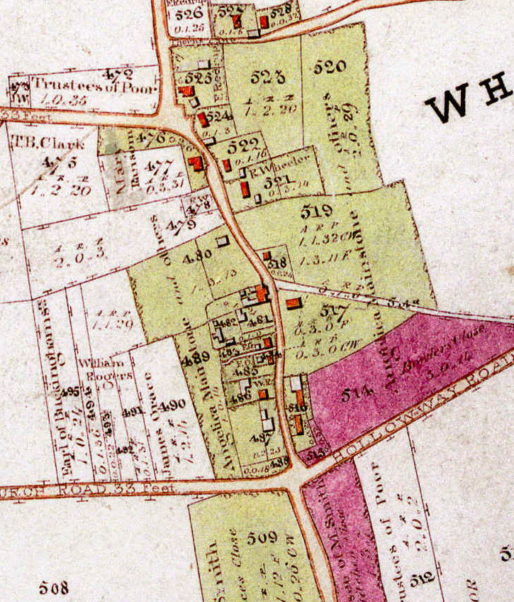
The 1839 Enclosure map showing all of White Cliff and Cadsden can be seen by clicking here. The centre of White Cliff is shown in detail in the map above and the few cottages of Cadsden are shown below. The current Holloway is marked as White Cliff Road and the current Peters Lane is shown as Church Road, running into Holloway Road. The old track of the Upper Icknield Way can be seen running across plots 517 and 519 (Whiteleaf House).
Of note in White Cliff are the Red Lion (plot 521), the owner and landlord of which at that time was R Wheeler of the Brewery/Pub owners Wheelers of Wycombe Brewery. 15 other dwellings are shown many of which still exist today. However the number of dwellings is deceptive as many of the buildings housed more than one family. Paxton Cottage was 2 separate cottages and Bakers Cottage was 3 separate cottages. There were in fact 28 separate families in White Cliff (according to the 1841 census) representing 97 men, women and children. The occupations of the men listed in the census are mainly agricultural labourer or sawyer and most of the women are listed as lacemakers.
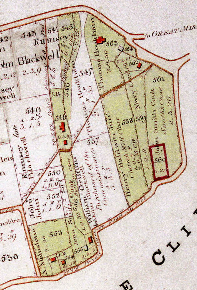
As for Cadsden, the only settlement was in the area around plots 562 to 563, which were known as Lower Cadsden and constituted Cadsden Cottage (now House). The Plough does not appear on the1839 map. Middle Cadsden constituted plot 548 and comprised two groups of cottages (one group of three and one of two). The group of two is still there today and is known as Middle Cadsden (although it was also confusingly known at one time as Cadsden Cottage). The area known as Upper Cadsden was represented by plots 553 to 555, where the Golf Clubhouse and Greenways stand today. The footpath which today crosses the golf course can clearly be seen. The North of the Cadsden Road was undeveloped and remained so until the early 20th Century.
In 1832/4 Thomas Rogers Parsons moved to Princes Risborough (living in the Market Square before moving to Whiteleaf House) and set up the Lion Brewery in the town. On his death in 1878 his properties passed to his son, Thomas Parsons, who continued to acquire other properties and land within Whiteleaf and Cadsden until the Estate was sold in 1903. For the detailed sales prospectus click here.
In May 1903 (as reported by the Bucks Herald) “on account of the very indifferent state of his health, and after leading a particularly active life in business, Mr. Parsons was anxious for a complete rest, to lay down the cares of an estate, and be free to travel for a time. Hence the sale of properties that “had taken two lifetimes to acquire” took place. Mr. Herbert Percy Davies Phillips of Wales and High Holborn purchased the greater part of the lots – see plan below – on offer for the grand sum of £9,500.
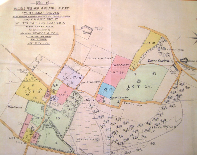
It is interesting to note that Lot 20 (where Up the Lane and Thorns Close now stand) was sold to Mr. Frank Job Chambers in the auction, but the sale was only completed in October 1903.
Herbert Phillips went on to acquire other parcels of land in Whiteleaf and Cadsden, notably the acreage below lot 13 in the above map. In 1904 his wife Mary Phillips set up the Whiteleaf Golf Course, which was originally a six hole course. When faced with a steep increase in death duties announced in 1916, Phillips gifted the club and the rest of the estate in October 1917 to his daughter Mrs. Mary Guinevere Davies Way.
In 1919 there were a number of transactions. Mary Way sold the Estate to Mr. George Macdonald Brown for £9,800 and he in turn sold it to Mr. William Joseph Ennever, founder of the Pelham Institute, for £13,625. In September 1919 Mr. Ennever put the Whiteleaf Estate up for sale by auction (for the detailed sales prospectus click here – also see plan below). The plan shows the Golf Course and that 3 properties had been built along the Upper Icknield Way (Red Roofs, Middle House and Romborough) and that specific building plots had been designated further along Upper Icknield Way. The plan also shows the location of a reservoir, which supplied some of the hamlet at that time.
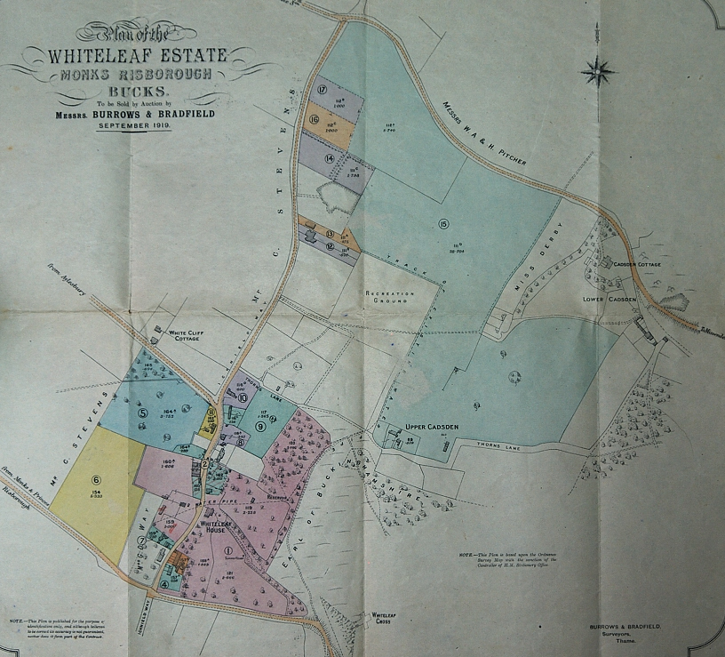
Prior to the sale, which took place in the George and Dragon Hotel in Princes Risborough on September 17th 1919, the largest lot – 1, Whiteleaf House, the farmery and 2 cottages as well as the Golf Course, were withdrawn from the sale and retained by Mr. Ennever.
The remainder of the Estate was sold to various buyers as reported in the Bucks Herald.
- Lot 2, Whiteleaf Cottage, with ground adjoining Lot 1, with vacant possession was secured by Miss Etherington at £1,050.
- Lot 3, half-timbered freehold cottages abutting on the Icknield Way now known as The Other, Box Tree and Felix Cottages as well as the barn which later housed the Gow Memorial Library was purchased by Rev. Gow, one of the tenants for £525.
- Lot 4 freehold cottages adjoining, now Lacey, The Middle and End Cottages was sold to Mr. F. H. Parrott for £420. Parrot also acquired Lot 6, 5acres, 1 rod, 13perches of arable land with 480ft frontage to the Monks Risborough road for £490 and Lot 13 a detached residence and garden adjoining occupied by Womersley for £1,000.
- Lot 5. Enclosure of meadowland, 4a. 1r. 3lp, with frontage of about 475ft. to the Aylesbury road, (where The White House amongst others now stands) was sold to Rev. Marsh Roberts for £410.
- Lot 6 5acres, 1 rod, 13perches, arable land with 480ft frontage to Monks Risborough road, Mr. Parrott £490.
- Lot 7 freehold cottage and shop occupied by Miss East (now Barn Cottage) was sold to Mr. F. J. Chambers for £300. Chambers also acquired Lot 10, three cottages, with large gardens and extensive frontage to the Icknield Way (now Bakers Cottage) for £380.
- Lot 8, pair of old fashioned cottages (now Paxton Cottage) was sold to Mr. C. Stevens of Prestwood for £180.
- Lot 9, pair picturesque cottages adjoining, with gardens (now Highrood and Cavall) and a paddock on which Bryony, Pipers Loft and The New House now stand) was sold to Mrs. Finlay for £875.
- Lot 11, Bijou cottage, with another cottage adjoining (Thatchers and Wood Cottage) was sold to Mr. G. M. Brown for £565.
- Lot 12, pair semi-detached freehold residences and gardens near the village, Mr. S. G. Dallas, one of the tenants, £1,650.
- Lot 14, freehold building site on the Icknield Way 1a. 3r. 8p.(now The Spinney) was bought by Mr. A. G. Gardiner for £260.
- Lot 16, another building plot, the same road, 1 acre, Mr. I. E. Hornby, £150.
The first properties were built in Westfields in 1923 (Crosskeys – now known as Woodside) and in 1925 (Windwhistle). However the beginning of the development started on 5th December 1918, when the Ecclesiastical Commissioners on behalf of the Oxford Diocese and for Monks Risborough Rectory sold 11 parcels of Glebe land including the Rectory Farm on the Aylesbury Road and outbuildings of 142 acres and 8 perches to Cornelius Stevens, of “The Limes” Prestwood for £4,000 – his family were well known butchers in the Amersham area until 1960’s.
Parcel 122, the West Field, was arable land and represents the land on which Westfield and the field originate. On the 21st November 1923 three parcels of land were sold off by Cornelius Stevens to a Winifred Kathleen Teagle of Prestwood for £120. These lots 13,14, and 15 (now Old Court, Badgers and Oakdene) were traded, but it was not until 1946 that the original building of Badgers actually took place.
In each of the conveyances/title deeds of the properties in Westfields there are a number of covenants including the following about the road; “The proposed road should be twelve feet wide with a space of six feet six inches wide for path on each side there of”. The road was known in 1946 as “Westfields”, then in 1955 “Brush Hill Road” and then back to “Westfield” in 1961.
1920s – The development of the Cadsden Road followed a similar pattern in that the land North of the Cadsden road was owned by William, Alfred Rufus and Herbert Pitcher, farmers of Great Kimble (as can be seen on the 1919 Whiteleaf Estate map above). They sold off parcels of land for building.
1926 – Whiteleaf obtained a mains water supply, which was crucial to the building of a number of new homes, when the “Rural Districts Water Company” built a reservoir tank near the Golf Club, pumping water from Monks Risborough. Prior to this, houses were largely on the site of old wells or supplied by the reservoir situated above Whiteleaf House mentioned above.
1948 – Sale of Whiteleaf House, which at that time still included substantial grounds on both sides of the Upper Icknield Way. Also included in the sale were the cottages Thatchers as well as Highrood and Melita(now Cavall), although the last pair were withdrawn and sold later in the same year. For detailed sales particulars click here.
1960s – Development of Whiteleaf Way (off the Upper Icknield Way). Four houses now stand on what was the kitchen garden of Whiteleaf House.
1974 – Development of Thorns Close on land previously owned by Up The Lane.
2.3 Other facts
As mentioned above, there are some features of Whiteleaf and Cadsden, which have not changed over the years. The Ragpit was originally designated as owned by “Surveyors of Highways,” the chalk extracted being used for the roads. The Ragpit is now owned by Princes Risborough Town.
In 1839, at the time of the Enclosure, certain plots of land were designated as for the benefit of the Community or the Poor. These plots, managed by the Monks Risborough Parochial Charities are rented out and the revenue used for worthwhile causes. Some of the plots which are now paddocks were at times also used as allotments.
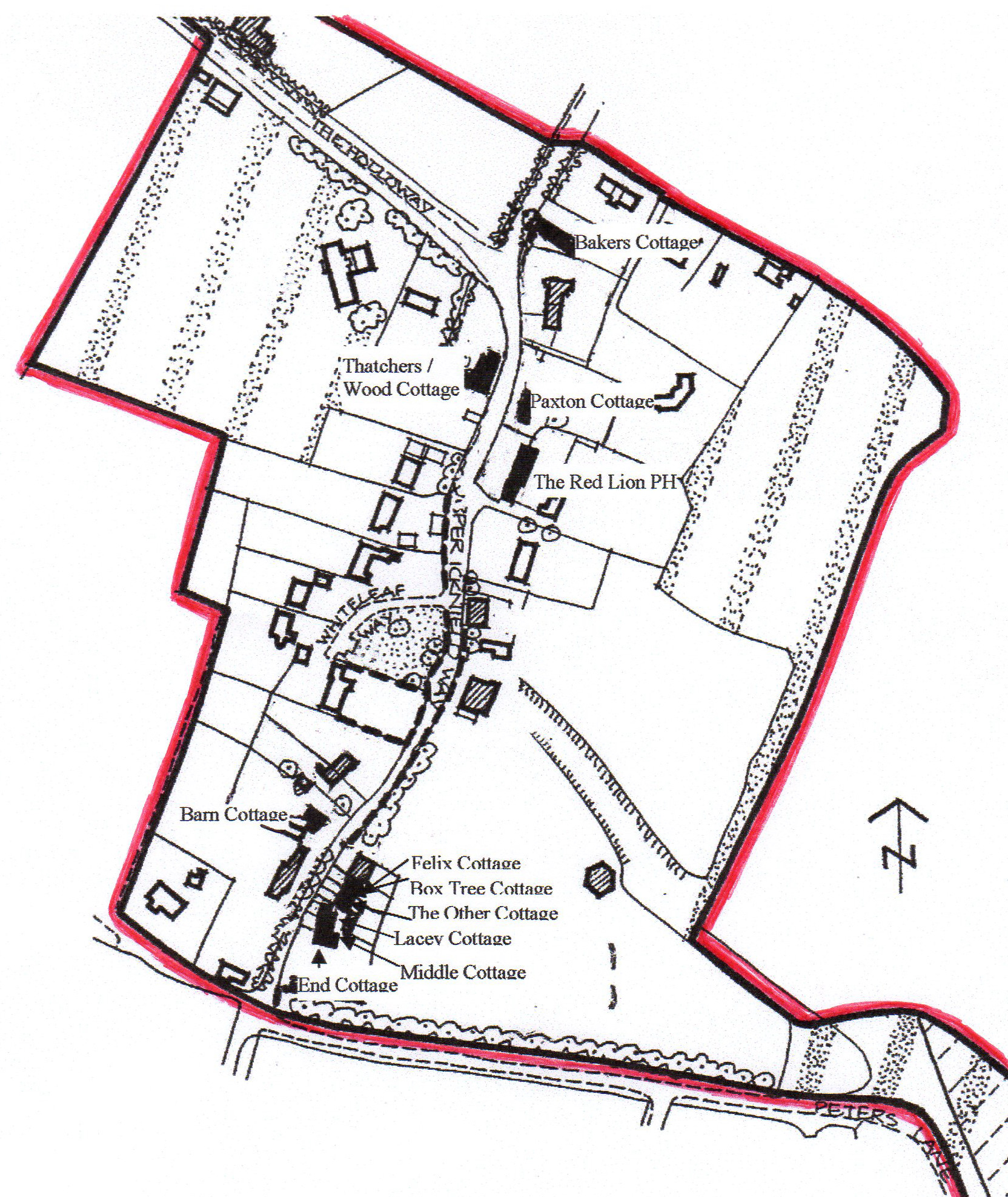
Whiteleaf was first designated as a conservation area in 1970. There are twelve listed dwellings in the conservation area, however the official list records only seven dwellings as the two terraces (comprising 6 houses) at the Peters Lane end of the Upper Icknield Way are listed as two items and Wood Cottage and Thatchers (which were in fact separate but are now one dwelling) are listed as one item. All the listings are grade II. A sketch of the conservation area is shown below, showing the listed buildings and outlining the boundary of the conservation area in red.The full Conservation Area Character Survey carried out by Wycombe District Council in 1996 can be accessed by clicking here.
